
Bourke > Attractions | History | Fred Hollows Grave Site | North Bourke Bridge ◦
Immortalised in both poetry and song, Bourke has a rich heritage, enticing travellers from around Australia and internationally to learn and experience the history of Bourke, learning about the early explorations, bushrangers, grazing industry, the legends, the poets and much more.
Check out the Bourke Attractions page for more information.
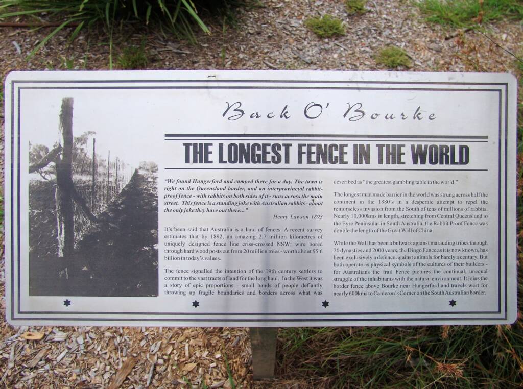
The Longest Fence in the World
“We found Hungerford and camped there for a day. The town is right on the Queensland border, and an interprovincial rabbit-proof fence – with rabbits on both sides of it – runs across the main street. This fence is a standing joke with Australian rabbits – about the only joke they have out there…”
Henry Lawson 1893
It’s been said that Australia is a land of fences. A recent survey estimates that by 1892, an amazing 2.7 million kilometres of uniquely designed fence line criss-crossed NSW; wire bored through hard wood posts cut from 20 million trees-worth about $5.6 billion in today’s values.
The fence signalled the intention of the 19th century settlers to commit to the vast tracts of land for the long haul. In the West it was a story of epic proportions – small bands of people defiantly throwing up fragile boundaries and borders across what was described as “the greatest gambling table in the world.”
The longest man made barrier in the world was strung across half the continent in the 1880’s in a desperate attempt to repel the remorseless invasion from the South of tens of millions of rabbits. Nearly 10,000 kms in length, stretching from Central Queensland to the Eyre Peninsular in South Australia, the Rabbit Proof Fence was double the length of the Great Wall of China.
While the Wall has been a bulwark against marauding tribes through 20 dynasties and 2000 years, the Dingo Fence as it is now known, has been exclusively a defence against animals for barely a century. But both operate as physical symbols of the cultures of their builders – for Australian the frail Fence pictures the continual, unqueal struggle of the inhabitants with the natural environment. It joins the border fence above Bourke near Hungerford and travels west for nearly 600 kms to Cameron’s Corner ont he South Australian border.
Source: Back O’ Bourke signage
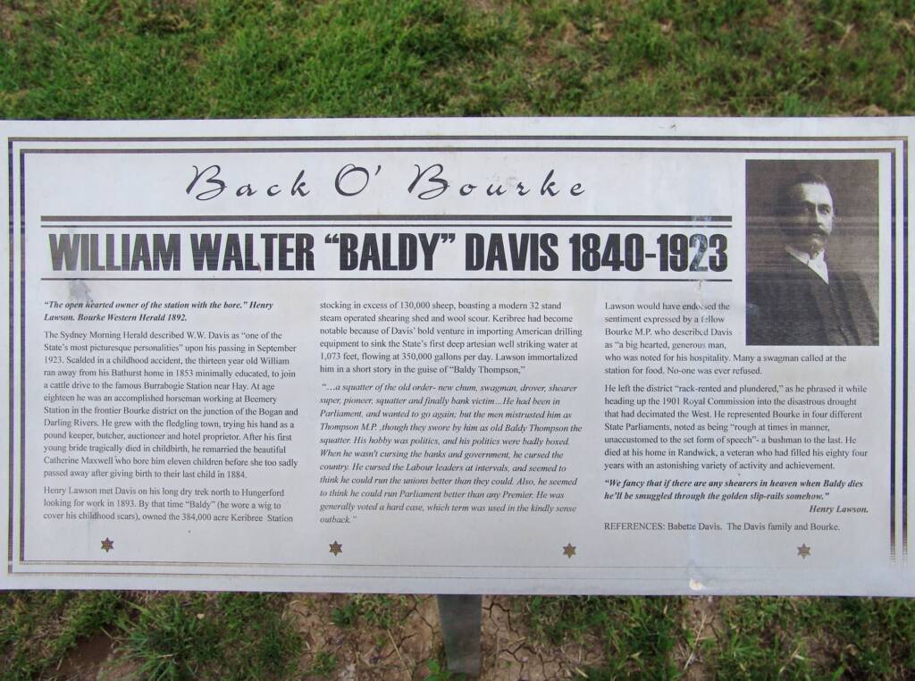
William Walter “Baldy” Davis 1840-1923
“The open hearted owner of the station with the bore.”
Henry Lawson. Bourke Western Herald 1892
The Sydney Morning Herald described W.W. Davis as “one of the State’s most picturesque personalities” upon his passing in September 1923. Scalded in a childhood accident, the thirteen year old William ran away from his Bathurst home in 1853 minimally educated, to join a cattle drive to the famous Burrabogie Station near Hay. At age eighteen he was an accomplished horseman working at Beemery Station in the frontier Bourke district on the junction of the Bogan and Darling Rivers. He grew up with the fledgling town, trying his hand as a pound keeper, butcher, auctioneer and hotel proprietor. After his first young bride tragically died in childbirth, he remarried the beautiful Catherine Maxwell who bore him eleven children before she too sadly passed away after giving birth to their last child in 1884.
Henry Lawson met Davis on his long dry trek north to Hungerford looking for work in 1893. By that time “Baldy” (he wore a wig to cover his childhood scars), owned the 384,000 acre Keribree Station stocking in excess of 130,000 sheep, boasting a modern 32 stand steam operated shearing shed and wool scour. Keribree had become notable because of Davis’ bold venture in importing American drilling equipment to sink the State’s first deep artesian well striking water at 1,073 feet, flowing at 350,000 gallons per day. Lawson immortalized him in a short story in the guise of “Baldy Thompson,”
“… a squatter of the old order- new chum, swagman, drover, shearer super, pioneer, suatter and finally bank victim… He had been in Parliament, and wanted to go again; but the men mistrusted him as Thompson M.P., though they swore by him as old Baldy Thompson the squatter. His hobby was politics, and his politics were badly boxed. When he wasn’t cursing the banks and government, he cursed the country. He cursed the Labour leaders at intervals, and seemed to think he could run the unions better than they could. Also, he seemed to think he could run Parliament better than any Premier. He was generally voted a hard case, which term was used in kiondly sense outback.”
Source: Back O’ Bourke signage
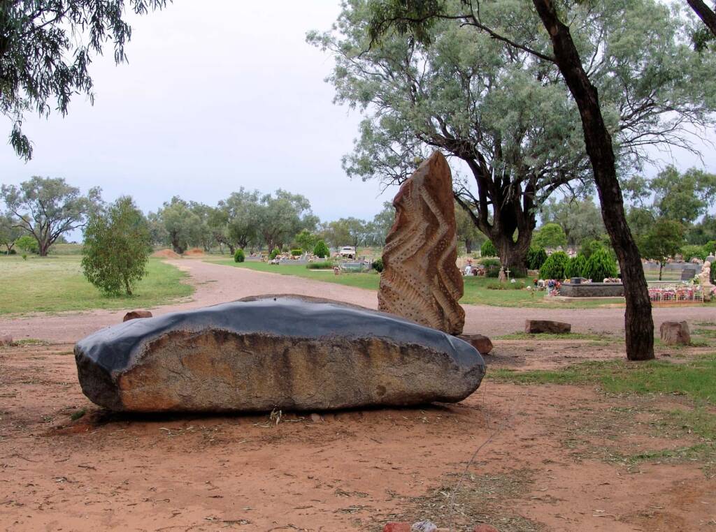
Bourke Cemetery
The cemetery contains many graves of historical interest, with the most famous being that of Fred Hollows. Also buried in the cemetery is Senior Constable McCabe, who was shot by Starlight, bush poet Francis Brown, and many other local characters. There are also a number of graves of Afghan camel drivers. These are easy to identify because, unlike the Christian graves, they are all pointing towards Mecca.
The Bourke General and Historic cemetery is located south of the township on the Cobar Rd (Kidman Way).
Bourke Lock and Weir
Darling River Near Bourke, BOURKE NSW 2840 – Opened in 1897, the Bourke Weir was the first to be built on the Darling River to ensure the water supply for the town. The lock, that allowed the paddleboats to bypass the weir, was the first in Australia and the only one ever built along the Darling River. At nearly 60 metres long and 11 metres wide, the lock was designed and built to control the level of water in the river near the town. In 1941, it was concreted and converted into the weir.
Extract:
The Bourke Lock and Weir – by Mr. A. E. Amphlett, B.E., Assoc. M. Inst., C.E.
(A Paper read before the Sydney University Engineering Society on December 8th, 1897)The Government of this Colony, recognising the extent to which the settlers and townspeople on the Darling are dependent upon an open river, have a snagging steamer at work at the present time. There is no doubt that, with a locked and permanently navigable river, a great impetus and development would take place in the western portions of the Colony.
Source: The University of Sydney – Sydney Escholarship
There is a fishing reserve covering the area downstream of the lock, including a public camping and barbecue area, with toilets. There are quite a few good fishing spots, further information and a map is available from the Visitors Centre.
Cobb & Co Heritage Trail – Bourke Area Trail
Bourke – it often seems to me, that the further you travel away from the cities, the closer you get to the past. To be drawn where the poets Henry Lawson and Breaker Morant were drawn – to the back of Bourke. Many of the roads have seen little change in 150 years; the vegetation and wildlife is often ‘as they would have seen it’. You will be reminded of the difficulties of the early explorers and of the Cobb & Co. coaching days when a trip from Bathurst to Bourke took three weeks and not six hours.
The Bathurst to Bourke Heritage Trail recalls the exciting times of Cobb & Co back in the 19th Century, before the telephone or the internet, when the Royal Mail Coach was the main link that settlers had with distant towns. Innovative and adaptable, the company was at the forefront of inland expansion and played a vital role in developing transport as well as social and communications networks across eastern Australia.
Today’s traveller can follow the award winning Cobb & Co Heritage Trail along highways and byways between Bathurst and Bourke and witness the relics of these long gone coaching days – many recognizable, some mere shadows of their former selves. Take the time to explore these fascinating areas, learn about Australia’s past and enjoy the journey making some exciting discoveries from the present along the way. You will only be limited by your imagination as you investigate the treasures of the Cobb & Co Heritage Trail.
Visit the Cobb & Co Heritage Trail website for more information, interactive maps, and where you can also choose from town trails and area trails. The website also has a collection of fantastic historical photos, as well as photos of coach building and restoration.
Source: Cobb & Co Heritage Trail – Bourke Area Trail
Fort Bourke Stockade
This re-creation of the Old Fort on the original site was first established in 1835 by Major Mitchell as a Fort-Cum-Depot, and named after the Governor of the colony, Sir Richard Bourke. Eventually the district and later the town came to be known by the name of Bourke. The area is bordered by the Darling River (north side) and a man-made lake and wildlife refuge (southeast to southwest).
Historic Buildings
There are many buildings of historic interest including:
- Carriers Arms Hotel (1879), frequented by Henry Lawson and mentioned in his poems. It was also a stop on the Cobb & Co coach route.
- Central Australian (late 1930’s)
- Courthouse (1899)
- Lands Department Building (1898)
- The London Bank (1888)
- Port of Bourke, formerly The Royal (ca. 1870)
- Post Office (1880)
- Telegraph Hotel (1875)
- The Western Herald (originally the Methodist Church), is considered to be the oldest standing building in Bourke.
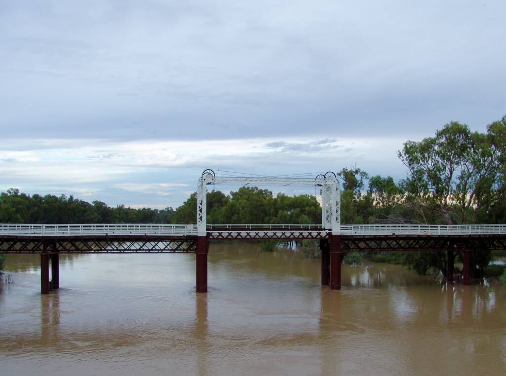
North Bourke Bridge
The North Bourke bridge is the bridge between the town of Bourke and its closest ‘suburb’, North Bourke. Built over a hundred years ago, this lift-up bridge was designed to allow paddle-steamers to pass through.
With the opening of the adjacent Darling River Gateway Bridge, the North Bourke lift-up bridge is now closed to traffic, although it is still in use as a footbridge.
See our article and images of North Bourke Bridge.
There is said to be 23 movable bridges built on the Murray-Darling river system, with very few remaining today. Other surviving pre 1915 lift bridges over the inland rivers include those on the Darling River at Wilcannia, NSW (1896), over the Murray River at Tocumwal, VIC (1895), Swan Hill, VIC (1896), Cobram, VIC (1902) and Barham, VIC (1905).
More information coming…