
Finke River System
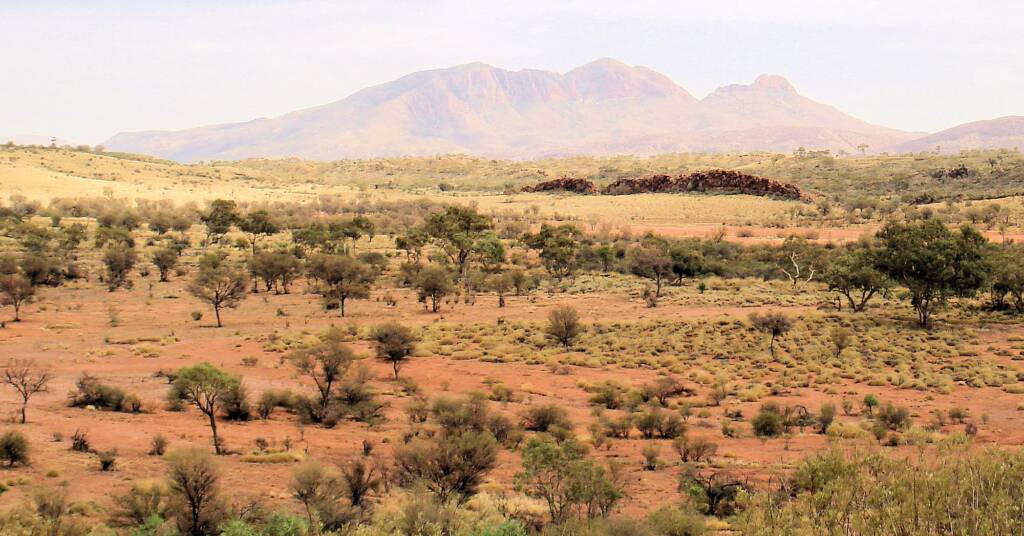
The Finke River and Finke River System is one of the largest river systems in Central Australia. Cited as being ‘the oldest river in the world’, it’s starts in the MacDonnell Ranges in the Northern Territory.
‘The Finke’ starts at the confluence of the Davenport and Ormiston Creeks, just north of popular Glen Helen. It then meanders for some 600 plus kilometres passing through the Finke Gorge National Park and like the Hugh, Palmer and Diamantina rivers all flowing inland, to the western edge of the Simpson Desert in northern part of South Australia and eventually ending up in Lake Eyre.
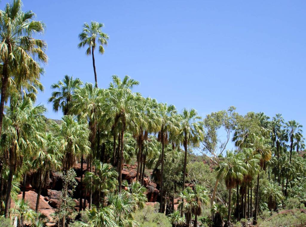
The Finke River winds pass Palm Valley, in fact, those visiting Palm Valley will find that part of the route is along the dry river bed of the Finke River. During times of heavy rain in the region, water flows through Palm Valley feeding into the Finke River. Check out some of our water images from Palm Valley.
The Finke River runs from the northwest to the southeast, joined by Ellery Creek and the two main tributaries, the Palmer River and the Hugh River. The Finke River starts at the confluence of the Davenport Creek and Ormiston Creek, just north of the popular Glen Helen. It then meanders for some 600 plus kilometres passing through the Finke Gorge National Park and like the Hugh, Palmer and Diamantina rivers all flowing inland, to the western edge of the Simpson Desert in northern part of South Australia and eventually ending up in Lake Eyre.
Some 15 million years ago the Finke River would have drained into Lake Eyre by cutting through the sediments of the Amadeus Basin. Now it releases into the sand plains of northern South Australia (Kerle, 1996).1
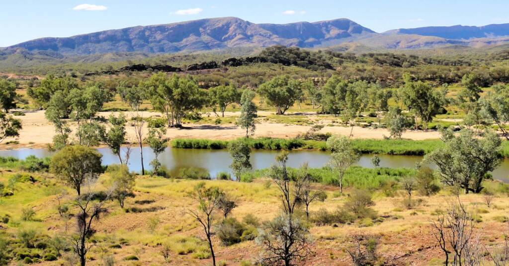
The Finke River, like many rivers in Central Australia, appear to be just a dry river bed. It is generally a broad sandy river bed with waterholes dotted along its length. There are nine permanent water holes along the route, important sources of water for local wildlife. In flood, the formerly dry river becomes a large, powerful torrent of water, sweeping debris, boulders, pebbles and sand in its path. The body of water could be short lived, flowing only for short periods, from hours to a couple of weeks, depending on the amount of rain, and where the water is flowing from.
Finke River System Attractions
There are a number of popular destinations found on and around the Finke River System including:
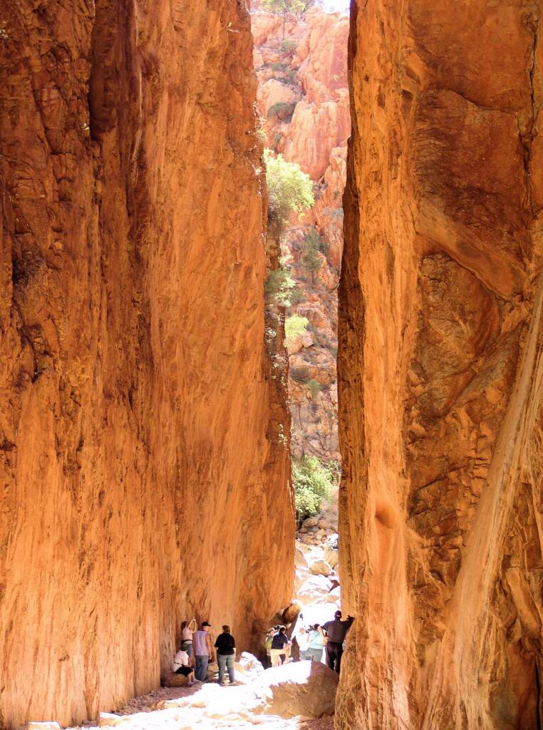
- Angkerle Atwatye (Standley Chasm)
Located 50 km by sealed road from Alice Springs, Standley Chasm has been gouged into touch sandstone by the floods that, over untold millions of years, have surged down a narrow tributary of the Finke River system. The result is a deep red cleft, with slopes on either side rising 80 metres above the floor.
- Boggy Hole
One of the permanent waterholes found along the Finke River. Located on the Finke River route about 2.5 hours from Palm Valley, the Boggy Hole is a large waterhole where visitors can experience bush camping (there are no facilities).
- Ellery Creek Big Hole
Part of the Finke River System, the Ellery Creek Big Hole is one of the largest permanent waterholes in the West MacDonnell National Park. Whilst it is known for plenty of water, in recent times, the water level has dropped considerably.
Located about an hour’s drives west of Alice Springs, along Namatjira Drive, the waterhole offers an important source of water for the local wildlife and a popular, refreshing stop for many locals and travellers and is a great place for a swim. The park also offers a great spot to camp, especially for those who are happy to ‘rough it’.
- Finke Gorge National Park
The park also includes part of the Finke River system, carving a path southwards through the surrounding desert ranges. As you travel along the often dry river bed, you can see evidence of pass torrents having carved its way through the land, often taking debris that get caught up and trapped at the base of many of the surviving River Red Gum and other eucalypts.
- Larapinta Trail
Officially opened in April 2002, this iconic walking trail cover a total of 223 km. Composed of 12 sections, the first section starts just west of Alice Springs, at the Telegraph Station through to Simpsons Gap. The western parts of this section pass through the catchment head of the Finke River. The trail runs along the backbone of the West MacDonnell Range and through the spectacular MacDonnell Range National Park, taking in Mount Sonder.
- Mount Sonder / Rwetyepme
Mount Sonder (at 1,380 metres above sea level), is the fourth highest point in Central Australia, after Mt Giles (1,389 metres), Mt Edwards (1,423 metres) and Mt Zeil (1,531 metres).
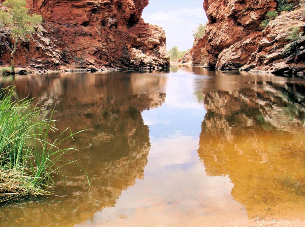
- Ormiston Pound / Ormiston Gorge
The Finke River passes Ormiston Gorge in the west and during times of rain, water can be seen in the river from the Mount Sonder Lookout.
- Palm Valley
World famous popular destination, with remnants of a tropical rainforest Red Cabbage Palm (Livistona mariae). Access to the valley is along part of the Finke River, in fact to cross and drive on the river several times. During the rare occasions of heavy rain, water flows through Palm Valley feeding into the Finke River.
- Simpson Desert, NT
Occupying the south eastern corner of the Northern Territory, the Simpson Desert is a large region of sand ridges, with an altitude dropping to under 200 m and a summer temperature that can exceed 50°C. It is part of a region that crosses borders, both into South Australia and Queensland. Several rivers including the Finke River start in the higher parts of the Northern Territory, before disappearing into the desert.
Heritage and Culture
The Finke River was named by John McDouall Stuart on 3 April 1860 during his fourth attempt to cross the Australian continent from south to north. Stuart named the Finke River ‘after my sincere friend William Finke, Esq. of Adelaide, South Australia – one of the liberal promoters of the different expeditions I have had the honor to lead’.2
In parts of the Northern Territory the indigenous name for the river is ‘Larapinta’. Depending on your source there appears to be a number of meanings for ‘Larapinta’ including snake and dry river bed. Another interpretation for the word ‘Larapinta’ or ‘Lirambenda’, is ‘creek with permanent water’. The Western Arrernte name for the river is spelt ‘Lhere-pirnte’, with ‘Lhere’ meaning ‘river’ and ‘pirnte’ meaning ‘salt’, hence ‘salty river’.
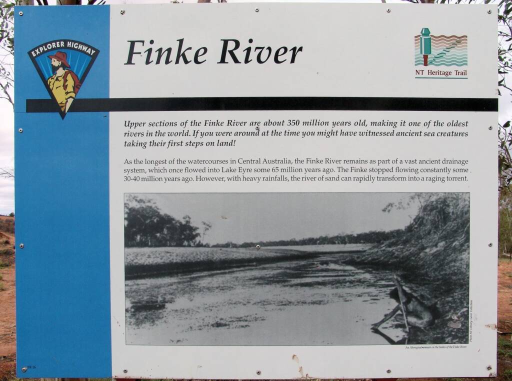
Upper sections of the Finke River are about 350 million years old, making it one of the oldest rivers in the world. If you were around at the time you might have witnessed ancient sea creatures taking their first steps on land! As the longest of the watercourses in Central Australia, the Finke River remains as part of a vast ancienht drainage system, which once flowed into Lake Eyre some 65 million years ago. The Finke stopped flowing constantly some 30-40 million years ago. However, with heavy rainfalls, the river of sand can rapidly transfer into a raging torrent.
Explorer Highway – NT Heritage Trail – Finke River
Photo NT Library: Laver Collection
An Aboriginal woman on the banks of the Finke River.
Interestingly, the above photo used in the signage can be seen in the State Library of South Australia, and although the signage mentions it is from the Laver Collection, the State Library of South Australia states the following:
Ref Finke River [PRG 1365/1/592] • Photograph
State Library of South Australia: Finke River [PRG 1365/1/592]
‘The Finke River – the grace of the rugged interior’. An Aboriginal man is on the river bank. According to a researcher, this photograph was not taken by Jack Laver, who was in Central Australia 1921-1926, but is a copy of a Baldwin Spencer / F.J. Gillen photo of 1896.
Footnote & References
- Australian Natural Resources Atlas: Rangelands – Overview. Landforms and hydrology (website no longer exists: original source url was www.anra.gov.au/topics/rangelands/overview/nt/ibra-fin.html)
- Northern Territory Land Information System (NTLIS): NT Place Names Register – Finke River